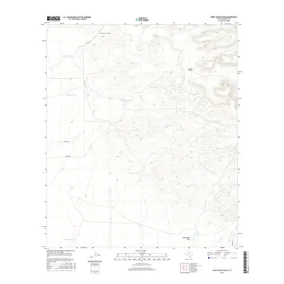
2016 Map of Sneed Mountain NE
USGS Topo · Published 2016About this map
Big Tank Ranch Airport serves as a lone modern landmark in this remote corner of Hudspeth County, where the landscape is defined by its arid drainage patterns and ranching infrastructure. The terrain is deeply inscribed by Apache Canyon to the northeast and the winding path of Witherspoon Draw in the south. Life in this high-desert environment centers on the management of water, evidenced by a dense network of catchment features including Uncle Sammy Tank, Rock Bottom Tank, and Railroad Tank. A few primary arteries like Big Tank Rd and Applegate Rd provide access across the high-elevation flats. The map documents the persistent ranching footprints of the region, where family-named features like Schuessler Tank and Little Parker Tank mark the points of human presence in an otherwise vast and unpopulated stretch of West Texas.
Find a feature on this map
20 named features on this map. Tap any name to fly to it.
Don’t see what you’re looking for? This feature index may not catch every label — zoom into the map to look around manually.
Map Details
Editions of this 2016 Sneed Mountain NE Map
This is the sole edition of this map. No revisions or reprints were ever made.
Other maps of this area

1895 · Sierra Blanca
USGS Topo · 1:125,000

1906 · Van Horn
USGS Topo · 1:125,000

1954 · Van Horn
USGS Topo · 1:250,000

1955 · Black Mountains
USGS Topo · 1:62,500

1958 · Van Horn
USGS Topo · 1:250,000

1973 · Norton Mesa
USGS Topo · 1:24,000

1973 · Bitter Well Mountain SW
USGS Topo · 1:24,000

1973 · Sneed Mountain NE
USGS Topo · 1:24,000

1973 · Apache Peak
USGS Topo · 1:24,000
1973 · Sneed Mountain
USGS Topo · 1:24,000