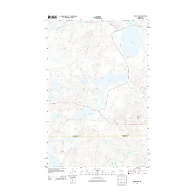
2013 Map of Snider Lake
USGS Topo · Published 2013About this map
Snider Lake sits at the heart of a dense network of glacial basins and watercourses along the boundary of Mahnomen and Becker counties. This 2013 survey reveals a landscape defined by its interconnected hydrology, where Tulaby Cr and Gull Creek weave through a mosaic of named water bodies like McCraney Lake, Wadena Lake, and the expansive S Twin and N Twin Lakes. The presence of the Tulaby Lookout Tower provides a fixed landmark overlooking the northern reaches of the White Earth Reservation area.
Find a feature on this map
34 named features on this map. Tap any name to fly to it.
Don’t see what you’re looking for? This feature index may not catch every label — zoom into the map to look around manually.
Map Details
Editions of this 2013 Snider Lake Map
This is the sole edition of this map. No revisions or reprints were ever made.
Other maps of this area

1954 · Bemidji
USGS Topo · 1:250,000

1957 · Bemidji
USGS Topo · 1:250,000

1958 · Bemidji
USGS Topo · 1:250,000

1969 · North Twin Lake
USGS Topo · 1:24,000

1969 · Many Point Lake
USGS Topo · 1:24,000

1969 · Roy Lake
USGS Topo · 1:24,000

1969 · Tulaby Lake
USGS Topo · 1:24,000
1969 · Ogema NE
USGS Topo · 1:24,000
1969 · Strawberry Lake
USGS Topo · 1:24,000

1969 · Snider Lake
USGS Topo · 1:24,000