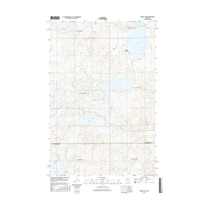
2016 Map of Snider Lake
USGS Topo · Published 2016About this map
Snider Lake and its surrounding waters dominate this glaciated landscape in the northwestern portion of Minnesota. The map illustrates a complex hydrographic network, including North Twin Lake, South Twin Lake, and the winding course of Tulaby Cr. This area, crossing the boundary between Mahnomen Co and Becker Co, showcases a transition from larger basins like White Earth Lake in the south to smaller, secluded waters such as Rooster Lake and Nest Lake. The local road system, featuring Snider Lk Rd and Co Rd 144, provides access to these shorelines, reflecting the region's importance for seasonal recreation and local transit. The topography is defined by numerous depressions and wetlands typical of the lake country, with Gull Cr and McCraney Lake serving as key nodes in the local drainage basin.
Find a feature on this map
45 named features on this map. Tap any name to fly to it.
Don’t see what you’re looking for? This feature index may not catch every label — zoom into the map to look around manually.
Map Details
Editions of this 2016 Snider Lake Map
This is the sole edition of this map. No revisions or reprints were ever made.
Other maps of this area

1954 · Bemidji
USGS Topo · 1:250,000

1957 · Bemidji
USGS Topo · 1:250,000

1958 · Bemidji
USGS Topo · 1:250,000

1969 · North Twin Lake
USGS Topo · 1:24,000

1969 · Many Point Lake
USGS Topo · 1:24,000

1969 · Roy Lake
USGS Topo · 1:24,000

1969 · Tulaby Lake
USGS Topo · 1:24,000
1969 · Ogema NE
USGS Topo · 1:24,000
1969 · Strawberry Lake
USGS Topo · 1:24,000

1969 · Snider Lake
USGS Topo · 1:24,000