
1943 Map of Snipe
USGS Topo · Published 1959About this map
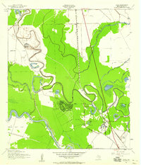
The Brazos River meanders through this portion of Brazoria County, defining a landscape of low-lying wetlands and oxbow lakes during the early 1940s. Significant land tracts are occupied by the Retrieve State Farm and Clemens State Farm, reflecting the region's historical agricultural prison system. Near the center, a newly planned residential grid for Lake Jackson appears adjacent to a "road under construction," signaling the rapid suburban development of the era driven by the nearby chemical industry. The map captures the transition from rural bottomlands to organized industry and settlement. Local social centers include Mt Zion Ch, Trueona Ch, and the Lake Jackson Sch, while the Missouri Pacific railroad serves as the primary transport spine for small stops like Snipe and Edmond Switch. The intricate waterways, including Oyster Creek and Bastrop Bayou, dominate the drainage pattern, punctuated by features like the Flood Gate and Artesian Well.
Find a feature on this map
39 named features on this map. Tap any name to fly to it.
Don’t see what you’re looking for? This feature index may not catch every label — zoom into the map to look around manually.
Map Details
Editions of this 1943 Snipe Map
2 editions found
Other maps of this area

1943 · Oyster Creek
USGS Topo · 1:31,680

1943 · Jones Creek
USGS Topo · 1:31,680

1943 · Danbury
USGS Topo · 1:31,680

1943 · Freeport
USGS Topo · 1:31,680

1943 · Angleton
USGS Topo · 1:24,000

1950 · Houston
USGS Topo · 1:250,000

1951 · Bay City
USGS Topo · 1:250,000

1952 · Cedar Lane NE
USGS Topo · 1:24,000

1952 · East Columbia
USGS Topo · 1:24,000

1952 · Brazoria
USGS Topo · 1:24,000