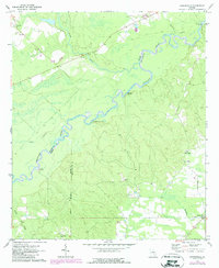
1971 Map of Snipesville
USGS Topo · Published 1988About this map
The Ocmulgee River meanders sharply across this landscape, serving as a defining boundary between Telfair, Jeff Davis, and Coffee counties. This 1971 survey, photorevised in 1988, highlights a river-based economy transitioning toward rural residential and agricultural land use. Several historical river access points, including Burket Ferry Landing, Haddock Landing, and Rocky Hammock Landing, are preserved in the topography, though their primary function as commercial crossings had largely faded by this period.
Find a feature on this map
22 named features on this map. Tap any name to fly to it.
Don’t see what you’re looking for? This feature index may not catch every label — zoom into the map to look around manually.
Map Details
Editions of this 1971 Snipesville Map
2 editions found
Other maps of this area

1953 · Waycross
USGS Topo · 1:250,000

1958 · Waycross
USGS Topo · 1:250,000

1971 · Roper
USGS Topo · 1:24,000

1971 · Jacksonville NE
USGS Topo · 1:24,000

1971 · Snipesville
USGS Topo · 1:24,000

1971 · Broxton NE
USGS Topo · 1:24,000

1971 · Denton
USGS Topo · 1:24,000
1971 · Lumber City
USGS Topo · 1:24,000

1972 · Broxton North
USGS Topo · 1:24,000

1972 · Jacksonville
USGS Topo · 1:24,000