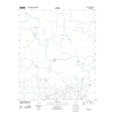
2011 Map of Snow Hill
USGS Topo · Published 2011About this map
The Smackover Oil and Gas Field dominates the southern landscape of this 2011 survey, illustrating the persistent industrial footprint of the region's energy resources. Settled pockets like Snow Hill and Joyce City are clustered near these production zones, while the northern terrain is defined by the winding course of the Ouachita River. This river corridor is a complex network of navigation hazards and oxbow formations, featuring named points such as Spoon Camp Shoals, Hog Eye Shoal, and English Bee Shoal. The area is heavily intersected by county roads and timber-related routes like Potlatch Rd, providing access to the dense bottomlands around Locust Bayou and Smackover Creek. From the elevation at Millers Bluff to the seasonal camps like Beech Springs Camp, the map captures a balance between the river's natural hydrology and the managed extraction of the southern Arkansas oil belt.
Find a feature on this map
51 named features on this map. Tap any name to fly to it.
Don’t see what you’re looking for? This feature index may not catch every label — zoom into the map to look around manually.
Map Details
Editions of this 2011 Snow Hill Map
This is the sole edition of this map. No revisions or reprints were ever made.
Other maps of this area

1903 · Camden
USGS Topo · 1:125,000

1951 · Camden
USGS Topo · 1:24,000

1953 · El Dorado
USGS Topo · 1:250,000

1957 · El Dorado
USGS Topo · 1:250,000

1958 · El Dorado
USGS Topo · 1:250,000

1960 · El Dorado
USGS Topo · 1:250,000

1962 · Lisbon
USGS Topo · 1:24,000

1962 · Louann
USGS Topo · 1:24,000

1962 · Smackover NE
USGS Topo · 1:24,000

1962 · Smackover
USGS Topo · 1:24,000