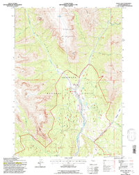
1991 Map of Snow Lake
USGS Topo · Published 1997About this map
Double Cabin sits at a strategic junction in the drainage basin where Wiggins Fork meets multiple mountain tributaries. This 1991 field-checked map illustrates the remote drainage network of the Shoshone National Forest, dominated by the high-elevation peaks of Norton Point and Crescent Top. The landscape is defined by the Washakie Wilderness boundary, which separates the more accessible lower reaches from the high backcountry. Historically significant routes like the Frontier Creek Trail and Wiggins Fork Trail follow the valley floors, providing access to secluded water bodies such as Snow Lake and Elk Lake. The map details the transition from the relatively open Caldwell Basin to the steep, narrow canyons carved by Cartridge Creek and Fire Creek, showing the intricate interplay of 4WD tracks and traditional pack trails.
Find a feature on this map
23 named features on this map. Tap any name to fly to it.
Don’t see what you’re looking for? This feature index may not catch every label — zoom into the map to look around manually.
Map Details
Editions of this 1991 Snow Lake Map
This is the sole edition of this map. No revisions or reprints were ever made.
Other maps of this area

1904 · Kirwin
USGS Topo · 1:125,000

1905 · Younts Peak
USGS Topo · 1:125,000

1906 · Kirwin
USGS Topo · 1:125,000

1907 · Younts Peak
USGS Topo · 1:125,000

1955 · Thermopolis
USGS Topo · 1:250,000

1956 · Indian Point
USGS Topo · 1:24,000

1956 · Ramshorn Peak
USGS Topo · 1:24,000

1956 · Snow Lake
USGS Topo · 1:24,000

1956 · Five Pockets
USGS Topo · 1:24,000

1956 · Emerald Lake
USGS Topo · 1:24,000