
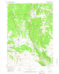
1956 Map of Indian Point
USGS Topo · Published 1958About this map
Shoshone National Forest defines this high-elevation landscape in the mid-1950s, where seasonal livestock management and remote homesteading shaped the local geography. The map captures a network of specialized mountain outposts, including the Rocking Chair Cow Camp and Spring Mountain Cow Camp, alongside family-named landmarks like the Simmerson Place and Eastman Place. These sites represent the vital summer grazing economy of the era, connected by a system of rugged paths such as the Wiggins Fork Trail and Indian Point Trail.
Find a feature on this map
38 named features on this map. Tap any name to fly to it.
Don’t see what you’re looking for? This feature index may not catch every label — zoom into the map to look around manually.
Map Details
Editions of this 1956 Indian Point Map
2 editions found
Other maps of this area

1904 · Kirwin
USGS Topo · 1:125,000

1905 · Younts Peak
USGS Topo · 1:125,000

1906 · Kirwin
USGS Topo · 1:125,000

1907 · Younts Peak
USGS Topo · 1:125,000

1955 · Thermopolis
USGS Topo · 1:250,000

1956 · Dubois
USGS Topo · 1:24,000

1956 · Ramshorn Peak
USGS Topo · 1:24,000

1956 · Snow Lake
USGS Topo · 1:24,000

1956 · Five Pockets
USGS Topo · 1:24,000

1956 · Mason Draw
USGS Topo · 1:24,000