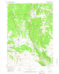
1956 Map of Indian Point
USGS Topo · Published 1967About this map
Shoshone National Forest defines this high-elevation landscape, where the Wiggins Fork cuts through deep valleys between Elkhorn Ridge and Indian Ridge. The map documents a working livestock landscape of the mid-1950s, characterized by isolated outposts such as Rocking Chair Cow Camp and Spring Mountain Cow Camp. These seasonal camps, along with the East Fork Elk Winter Pasture Hdqrs, reveal the spatial organization of high-country ranching before modern infrastructure dominated the region.
Find a feature on this map
39 named features on this map. Tap any name to fly to it.
Don’t see what you’re looking for? This feature index may not catch every label — zoom into the map to look around manually.
Map Details
Editions of this 1956 Indian Point Map
2 editions found
Other maps of this area

1904 · Kirwin
USGS Topo · 1:125,000

1905 · Younts Peak
USGS Topo · 1:125,000

1906 · Kirwin
USGS Topo · 1:125,000

1907 · Younts Peak
USGS Topo · 1:125,000

1955 · Thermopolis
USGS Topo · 1:250,000

1956 · Indian Point
USGS Topo · 1:24,000

1956 · Dubois
USGS Topo · 1:24,000

1956 · Ramshorn Peak
USGS Topo · 1:24,000

1956 · Snow Lake
USGS Topo · 1:24,000

1956 · Five Pockets
USGS Topo · 1:24,000