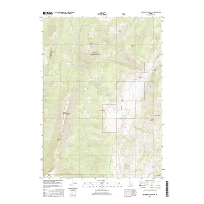
2017 Map of Snowdrift Mountain
USGS Topo · Published 2017About this map
Snowdrift Mountain and the high ridges of the Preuss Range dominate this southeastern Idaho landscape within the Caribou National Forest. The map detail reveals a complex network of forest roads, such as Caribou NF Rd 111 and Crow Creek Rd, which provide access to the remote canyons and valleys that define this terrain. The drainage patterns are highly detailed, showing the headwaters of Crow Creek and Georgetown Creek, alongside numerous named springs like Goodhart Spring and Greyhound Pass Spring. Geologically significant areas such as Phosphoria Gulch and the Gannett Hills suggest the region's rich mineral and natural history. This data is essential for understanding the management of public lands and the preservation of watershed systems between the Webster Range and the Bear Lake County border.
Find a feature on this map
44 named features on this map. Tap any name to fly to it.
Don’t see what you’re looking for? This feature index may not catch every label — zoom into the map to look around manually.
Map Details
Editions of this 2017 Snowdrift Mountain Map
This is the sole edition of this map. No revisions or reprints were ever made.
Other maps of this area

1909 · Montpelier
USGS Topo · 1:125,000

1911 · Montpelier
USGS Topo · 1:125,000

1911 · Slug Creek
USGS Topo · 1:62,500

1915 · Crow Creek
USGS Topo · 1:62,500

1949 · Stewart Flat
USGS Topo · 1:24,000

1949 · Dry Valley
USGS Topo · 1:24,000

1949 · Snowdrift Mountain
USGS Topo · 1:24,000

1951 · Stewart Flat
USGS Topo · 1:24,000
1951 · Dry Valley
USGS Topo · 1:24,000
1951 · Snowdrift Mountain
USGS Topo · 1:24,000