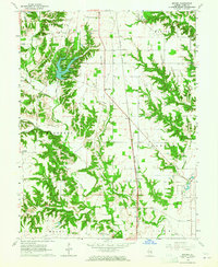
1964 Map of Snyder
USGS Topo · Published 1965About this map
Lincoln Trail State Park dominates the northwest quadrant of this Clark County map, centered on its reservoir and the winding drainages that feed it. The landscape is defined by the heavy dissection of Mill Creek and its many tributaries, including Auburn Branch and Sandy Branch, which carve through the till plains. The New York Central railroad provides a straight linear axis through the center of the sheet, connecting small stopping points like Ernst and Snyder. Genealogists will find numerous family-centric landmarks and small burial sites, such as Knott Cem and Ziegler Cem, often located on the higher ground between the branching creek systems. The survey reveals a rural economy focused on timbered stream valleys and upland agriculture, punctuated by local landmarks like Grand Turn and Emmanuel Ch.
Find a feature on this map
35 named features on this map. Tap any name to fly to it.
Don’t see what you’re looking for? This feature index may not catch every label — zoom into the map to look around manually.
Map Details
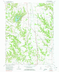
Editions of this 1964 Snyder Map
2 editions found
Other maps of this area

1932 · Marshall
USGS Topo · 1:62,500

1936 · Casey
USGS Topo · 1:48,000

1937 · Marshall
USGS Topo · 1:62,500

1942 · Fairbanks
USGS Topo · 1:24,000

1942 · Hutton
USGS Topo · 1:24,000

1942 · Dennison
USGS Topo · 1:24,000

1942 · Casey
USGS Topo · 1:62,500

1943 · Casey
USGS Topo · 1:62,500

1952 · Fairbanks
USGS Topo · 1:24,000
1952 · Hutton
USGS Topo · 1:24,000