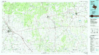
1985 Map of Snyder
USGS Topo · Published 1985About this map
The rolling plains of West Texas are defined by the convergence of the Double Mountain Fork Brazos River and the Clear Fork Brazos River in this mid-1980s map. The regional hub of Snyder sits at the intersection of major rail lines, including the Atchison Topeka and Santa Fe and the Roscoe Snyder and Pacific. This era captures the area's transition into a modern petroleum and educational center, anchored by Western Texas College and served by aviation facilities like Winston Field. Beyond the city limits, the landscape is dotted with smaller communities and agricultural outposts such as Hermleigh, Claytonville, and Rotan. The southern edge of the survey reaches toward the industrial and transport nodes of Sweetwater, while the north and west are characterized by distinct landforms like the Mc Kenzie Mountains and Cox Hollow.
Find a feature on this map
80 named features on this map. Tap any name to fly to it.
Don’t see what you’re looking for? This feature index may not catch every label — zoom into the map to look around manually.
Map Details
Editions of this 1985 Snyder Map
2 editions found
Other maps of this area

1890 · Abilene
USGS Topo · 1:125,000

1891 · Anson
USGS Topo · 1:125,000

1892 · Abilene
USGS Topo · 1:125,000

1893 · Roby
USGS Topo · 1:125,000

1893 · Anson
USGS Topo · 1:125,000

1893 · Sweetwater
USGS Topo · 1:125,000

1926 · Snyder 1-a
USGS Topo · 1:48,000

1926 · Roby 2-b
USGS Topo · 1:48,000

1931 · Rotan
USGS Topo · 1:62,500

1931 · Aspermont
USGS Topo · 1:62,500