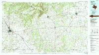
1985 Map of Snyder
USGS Topo · Published 1988About this map
The Double Mountain Fork Brazos River and Colorado River define the drainage of this West Texas landscape during the mid-1980s. Centered on the hub of Snyder, the map illustrates a region where ranching and energy interests meet, with the Atchison Topeka and Santa Fe railroad providing a vital corridor through Hermleigh and Pyron. The presence of Western Texas College and Winston Field marks the growth of Snyder, while smaller crossroads like Camp Springs, Claytonville, and Hobbs preserve the rural character of the surrounding plains.
Find a feature on this map
84 named features on this map. Tap any name to fly to it.
Don’t see what you’re looking for? This feature index may not catch every label — zoom into the map to look around manually.
Map Details
Editions of this 1985 Snyder Map
2 editions found
Other maps of this area

1890 · Abilene
USGS Topo · 1:125,000

1891 · Anson
USGS Topo · 1:125,000

1892 · Abilene
USGS Topo · 1:125,000

1893 · Roby
USGS Topo · 1:125,000

1893 · Anson
USGS Topo · 1:125,000

1893 · Sweetwater
USGS Topo · 1:125,000

1926 · Snyder 1-a
USGS Topo · 1:48,000

1926 · Roby 2-b
USGS Topo · 1:48,000

1931 · Rotan
USGS Topo · 1:62,500

1931 · Aspermont
USGS Topo · 1:62,500