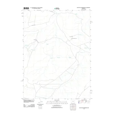
2012 Map of Soap Holes Reservoir
USGS Topo · Published 2012About this map
Soap Holes Reservoir and a network of high-desert water management features define this stretch of the Wyoming landscape. This 2012 survey details a region shaped by both natural drainage and industrial extraction, where ephemeral channels like Dry Cr and Big Hollow Cr are punctuated by man-made impoundments such as Hordeum Reservoir and Dobie Reservoir. The map reveals the imprint of local industry through the Standard Pit and East Fork Pit Number 3, which sit alongside the infrastructure of Cedar Mountain Rd. Topographic features like Big Hollow Bench provide a sense of the arid elevation shifts characteristic of this part of Sweetwater County, while names like Buck Basin Reservoir reflect the functional naming conventions of the high plains.
Find a feature on this map
18 named features on this map. Tap any name to fly to it.
Don’t see what you’re looking for? This feature index may not catch every label — zoom into the map to look around manually.
Map Details
Editions of this 2012 Soap Holes Reservoir Map
This is the sole edition of this map. No revisions or reprints were ever made.
Other maps of this area

1954 · Ogden
USGS Topo · 1:250,000

1954 · Rock Springs
USGS Topo · 1:250,000

1958 · Ogden
USGS Topo · 1:250,000

1958 · Rock Springs
USGS Topo · 1:250,000

1960 · Ogden
USGS Topo · 1:250,000

1962 · Rock Springs
USGS Topo · 1:250,000

1964 · Butcher Knife Draw
USGS Topo · 1:24,000
1964 · Mc Kinnon
USGS Topo · 1:24,000

1964 · Soap Holes Reservoir
USGS Topo · 1:24,000

1964 · Reed Reservoir
USGS Topo · 1:24,000