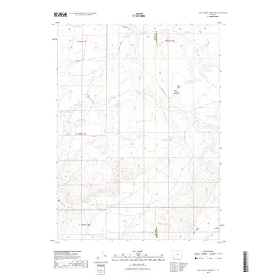
2017 Map of Soap Holes Reservoir
USGS Topo · Published 2017About this map
The high desert terrain of southwestern Wyoming is defined here by a network of drainage systems and man-made water catchments along the Uinta Co Sweetwater Co line. Significant features such as Soap Holes Reservoir and Standard Reservoir highlight the critical role of water management in this arid landscape. The area shows evidence of resource extraction at the Standard Pit and East Fork Pit Number 3, while landforms like Sage Creek Mtn and Big Hollow Bench create a complex topography. Local infrastructure is represented by primitive roads such as Cedar Mountain Rd and Hank Hollow Rd, which navigate the draws of Dry Cr and Big Hollow Cr. This modern survey documents the continued use of the land for grazing and mineral interest, featuring numerous catchments like Dobie Reservoir and Hordeum Reservoir scattered across the high plains.
Find a feature on this map
28 named features on this map. Tap any name to fly to it.
Don’t see what you’re looking for? This feature index may not catch every label — zoom into the map to look around manually.
Map Details
Editions of this 2017 Soap Holes Reservoir Map
This is the sole edition of this map. No revisions or reprints were ever made.
Other maps of this area

1954 · Ogden
USGS Topo · 1:250,000

1954 · Rock Springs
USGS Topo · 1:250,000

1958 · Ogden
USGS Topo · 1:250,000

1958 · Rock Springs
USGS Topo · 1:250,000

1960 · Ogden
USGS Topo · 1:250,000

1962 · Rock Springs
USGS Topo · 1:250,000

1964 · Butcher Knife Draw
USGS Topo · 1:24,000
1964 · Mc Kinnon
USGS Topo · 1:24,000

1964 · Soap Holes Reservoir
USGS Topo · 1:24,000

1964 · Reed Reservoir
USGS Topo · 1:24,000