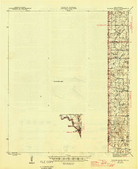
1945 Map of Socagee Bayou
USGS Topo · Published 1945About this map
The Sabine River forms a jagged border between Texas and Louisiana in this mid-1940s survey, anchoring a rural landscape of creek bottoms and small community centers. To the north, Socagee Bayou and Little Creek drain the terrain toward the river, while a distinct Unsurveyed Area occupies a significant portion of the western Panola County section. This absence of topographic data emphasizes the era's ongoing mapping efforts in the more remote reaches of the borderlands.
Find a feature on this map
29 named features on this map. Tap any name to fly to it.
Don’t see what you’re looking for? This feature index may not catch every label — zoom into the map to look around manually.
Map Details
Editions of this 1945 Socagee Bayou Map
2 editions found
Other maps of this area

1943 · Waskom
USGS Topo · 1:62,500

1944 · Logansport
USGS Topo · 1:62,500

1945 · Grand Cane
USGS Topo · 1:62,500

1945 · Waskom
USGS Topo · 1:62,500

1945 · Greenwood
USGS Topo · 1:62,500

1945 · Socagee Bayou
USGS Topo · 1:62,500

1953 · Alexandria
USGS Topo · 1:250,000

1953 · Palestine
USGS Topo · 1:250,000

1955 · Shreveport
USGS Topo · 1:250,000

1955 · Alexandria
USGS Topo · 1:250,000