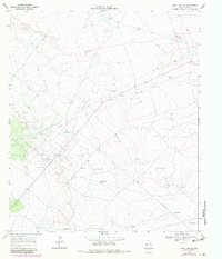
1968 Map of Soda Lake SE
USGS Topo · Published 1981About this map
The Quito Oil Field and Poquito Oil Field anchor this West Texas landscape in Ward County, revealing an economy defined by petroleum extraction and water management. Mapping by the Texas Water Development Board and USGS highlights the critical infrastructure required for survival and industry in this arid environment. A dense network of pipelines crisscrosses the terrain, connecting numerous Oil Wells and Gravel Pits. Water sources are meticulously documented, from family-named landmarks like Yarbro Well and Hays Windmill to functional livestock or industrial points such as Middle Well and Division Well. The distribution of resources is further marked by several catchments, including the descriptively named Tank on the Hill, Sand Tank, and First Tank, illustrating the sparse but vital settlement pattern of the Permian Basin during the late 1960s.
Find a feature on this map
19 named features on this map. Tap any name to fly to it.
Don’t see what you’re looking for? This feature index may not catch every label — zoom into the map to look around manually.
Map Details
Editions of this 1968 Soda Lake SE Map
2 editions found
Other maps of this area

1931 · Barstow
USGS Topo · 1:125,000

1954 · Pecos
USGS Topo · 1:250,000

1957 · Pecos
USGS Topo · 1:250,000

1961 · Soda Lake
USGS Topo · 1:24,000

1963 · Quito Draw
USGS Topo · 1:24,000

1963 · China Lake
USGS Topo · 1:24,000

1963 · Pecos East
USGS Topo · 1:24,000

1967 · Soda Lake NW
USGS Topo · 1:24,000

1968 · Soda Lake SE
USGS Topo · 1:24,000

1968 · Wink South
USGS Topo · 1:24,000