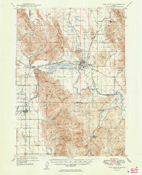
1949 Map of Soda Springs
USGS Topo · Published 1949About this map
Soda Springs serves as the central hub of this late-1940s survey, situated where the Oregon Trail met the Oregon Short Line. The map reveals a landscape defined by volcanic geology and mineral extraction, featuring the Conda Mine and the distinctive Alexander Crater. Historical memory is etched into the terrain at the Wagonbox Grave and a Historic Marker near the Soda Point Reservoir.
Find a feature on this map
63 named features on this map. Tap any name to fly to it.
Don’t see what you’re looking for? This feature index may not catch every label — zoom into the map to look around manually.
Map Details
Editions of this 1949 Soda Springs Map
4 editions found

Other maps of this area

1909 · Montpelier
USGS Topo · 1:125,000

1911 · Montpelier
USGS Topo · 1:125,000

1911 · Slug Creek
USGS Topo · 1:62,500

1914 · Henry
USGS Topo · 1:48,000

1915 · Preston
USGS Topo · 1:96,000

1915 · Lanes Creek
USGS Topo · 1:62,500

1916 · Henry
USGS Topo · 1:62,500

1917 · Portneuf
USGS Topo · 1:62,500

1918 · Preston
USGS Topo · 1:125,000

1948 · Bancroft
USGS Topo · 1:62,500