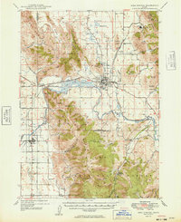
1949 Map of Soda Springs
USGS Topo · Published 1949About this map
The Bear River carves a path through the heart of the Caribou County landscape, winding south from Soda Springs toward the settlement of Grace. This 1940s survey documents a region defined by its volcanic geology and pioneer heritage, featuring the Alexander Crater and the notable Wagon Box Grave. The local economy is represented by industrial footprints at the Conda Mine and the Idaho Sulphur Mine, while the transportation network shows the evolution of the western migration routes.
Find a feature on this map
73 named features on this map. Tap any name to fly to it.
Don’t see what you’re looking for? This feature index may not catch every label — zoom into the map to look around manually.
Map Details
Editions of this 1949 Soda Springs Map
4 editions found

Other maps of this area

1909 · Montpelier
USGS Topo · 1:125,000

1911 · Montpelier
USGS Topo · 1:125,000

1911 · Slug Creek
USGS Topo · 1:62,500

1914 · Henry
USGS Topo · 1:48,000

1915 · Preston
USGS Topo · 1:96,000

1915 · Lanes Creek
USGS Topo · 1:62,500

1916 · Henry
USGS Topo · 1:62,500

1917 · Portneuf
USGS Topo · 1:62,500

1918 · Preston
USGS Topo · 1:125,000

1948 · Bancroft
USGS Topo · 1:62,500