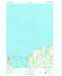
1953 Map of Sodus Point
USGS Topo · Published 1974About this map
Lake Ontario's shoreline is defined by a series of barrier beaches and islands in this mid-century survey of the Wayne County coast. The village of Sodus Point stands as a primary hub, where the Pennsylvania railroad line terminates at the water's edge, reflecting its historical role as a transit point for Great Lakes commerce. The map meticulously details the complex geography of Sodus Bay, featuring several prominent landmasses including Newark Island, Eagle Island, and Le Roy Island.
Find a feature on this map
26 named features on this map. Tap any name to fly to it.
Don’t see what you’re looking for? This feature index may not catch every label — zoom into the map to look around manually.
Map Details
Editions of this 1953 Sodus Point Map
4 editions found
Other maps of this area

1899 · Palmyra
USGS Topo · 1:62,500

1902 · Sodus Bay
USGS Topo · 1:62,500

1902 · Pultneyville
USGS Topo · 1:62,500

1902 · Clyde
USGS Topo · 1:62,500

1902 · Palmyra
USGS Topo · 1:62,500

1943 · Sodus Point
USGS Topo · 1:31,680

1943 · Sodus
USGS Topo · 1:31,680

1943 · Wolcott
USGS Topo · 1:31,680
1943 · Rose
USGS Topo · 1:31,680
1943 · North Wolcott
USGS Topo · 1:31,680