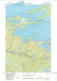
1968 Map of Soldier Point
USGS Topo · Published 1983About this map
Voyageurs National Park defines this aquatic landscape on the international border between Ontario and Minnesota. The topography is a dense network of interconnected water bodies and glacial islands, where the Canada-United States boundary threads through the Narrows and past Brule Island. To the south, a chain of smaller interior lakes including Locator Lake, War Club Lake, and Quill Lake are linked by portage trails, reflecting the traditional travel routes of the north woods. The map highlights the intricate shoreline of Soldier Point Lake and Saginaw Bay, where numerous named points and islands like Kawawia Island and Finlander Island provide specific landmarks for navigation. This 1968 survey, with revisions from 1981, documents the shoreline and wilderness character of the Rainy River District before modern development altered these boundary waters.
Find a feature on this map
37 named features on this map. Tap any name to fly to it.
Don’t see what you’re looking for? This feature index may not catch every label — zoom into the map to look around manually.
Map Details
Editions of this 1968 Soldier Point Map
2 editions found
Other maps of this area

1954 · International Falls
USGS Topo · 1:250,000

1957 · International Falls
USGS Topo · 1:250,000

1958 · International Falls
USGS Topo · 1:250,000

1967 · Kempton Bay
USGS Topo · 1:24,000

1968 · Soldier Point
USGS Topo · 1:24,000

1968 · Daley Bay
USGS Topo · 1:24,000

1968 · Ash River NE
USGS Topo · 1:24,000

1969 · Cranberry Bay
USGS Topo · 1:24,000

1969 · Kabetogama
USGS Topo · 1:24,000
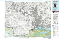
1978 · International Falls
USGS Topo · 1:100,000