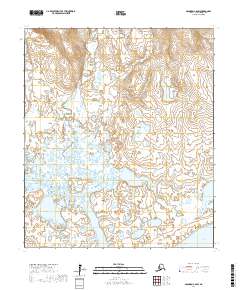
2017 Map of Solomon C-6 SW
USGS Topo · Published 2017About this map
The Seward Peninsula landscape is defined by the braided and meandering courses of the Eldorado River and Flambeau River as they flow south toward the Bering Sea. In this subarctic coastal environment, the terrain is a complex network of wetlands and small kettle lakes, including Fox Lake, that terminate at the saltwater margin of Safety Sound. The transition from the inland hills, drained by Beaver Cr and Volunteer Cr, to the low-lying coastal plains reveals a dynamic hydrological system where river channels shift over time across the permafrost-influenced soil. The map provides a clear look at the intricate drainage patterns of the Nome Census Area, showing the intersection of freshwater river systems and the coastal lagoon environment before they meet the open sea.
Find a feature on this map
13 named features on this map. Tap any name to fly to it.
Don’t see what you’re looking for? This feature index may not catch every label — zoom into the map to look around manually.
Map Details
Editions of this 2017 Solomon C-6 SW Map
This is the sole edition of this map. No revisions or reprints were ever made.
Other maps of this area

1950 · Nome
USGS Topo · 1:250,000

1950 · Solomon C-6
USGS Topo · 1:63,360

1950 · Nome B-1
USGS Topo · 1:63,360

1950 · Solomon B-6
USGS Topo · 1:63,360

1950 · Solomon
USGS Topo · 1:250,000

1950 · Nome C-1
USGS Topo · 1:63,360

1951 · Nome
USGS Topo · 1:250,000

1951 · Solomon
USGS Topo · 1:250,000

1957 · Nome
USGS Topo · 1:250,000
2014 · Solomon B-6 NE
USGS Topo · 1:25,000