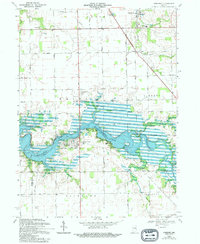
1969 Map of Somerset
USGS Topo · Published 1994About this map
Mississinewa Lake dominates this Indiana landscape, its sprawling waters filling the valley where the Mississinewa River once flowed more freely. The town of Somerset sits near the southwestern reaches of the reservoir, while the northern uplands reveal a rural network of farmsteads and schools like Southwood High Sch. Genealogists will find notable burial sites including Martin Luther Cem near Lebanon Ch and the Mississinewa Memorial Cemetery situated further south. The topography is defined by the carved path of the river and its many tributaries, such as Treaty Creek and Grant Creek. Recreation areas like the Pearson Mill Public Use Area and Hogback Bridge Public Use Area highlight the transition of this area into a public water resource and parkland, even as older settlements like Treaty and White Institute maintain their presence on the surrounding high ground.
Find a feature on this map
38 named features on this map. Tap any name to fly to it.
Don’t see what you’re looking for? This feature index may not catch every label — zoom into the map to look around manually.
Map Details
Editions of this 1969 Somerset Map
3 editions found
Other maps of this area

1950 · Lagro
USGS Topo · 1:24,000

1951 · Lagro
USGS Topo · 1:24,000

1951 · Richvalley
USGS Topo · 1:24,000

1952 · Wabash
USGS Topo · 1:24,000

1953 · La Fontaine
USGS Topo · 1:24,000

1953 · Somerset
USGS Topo · 1:24,000

1953 · Peoria
USGS Topo · 1:24,000

1953 · Muncie
USGS Topo · 1:250,000

1956 · Muncie
USGS Topo · 1:250,000

1961 · Marion
USGS Topo · 1:24,000