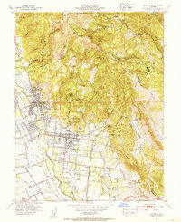
1951 Map of Sonoma
USGS Topo · Published 1952About this map
The Pueblo Lands of Sonoma form the heart of this mid-century survey, showcasing a landscape transitioning from its deep Spanish and Mexican heritage into a modern viticultural and residential hub. Central to the map is the town of Sonoma, where historical legacy is anchored by the Vallejo Home State Historical Monument and the Mission San Francisco Solano Vineyard. These landmarks signify the early 19th-century roots of the region's agricultural identity long before the post-war suburban shift.
Find a feature on this map
59 named features on this map. Tap any name to fly to it.
Don’t see what you’re looking for? This feature index may not catch every label — zoom into the map to look around manually.
Map Details
Editions of this 1951 Sonoma Map
4 editions found
Other maps of this area

1902 · Napa
USGS Topo · 1:125,000

1914 · Petaluma
USGS Topo · 1:62,500

1916 · Mare Island
USGS Topo · 1:62,500

1916 · Santa Rosa
USGS Topo · 1:62,500

1942 · Mare Island
USGS Topo · 1:62,500

1942 · Sonoma
USGS Topo · 1:62,500

1942 · Petaluma
USGS Topo · 1:62,500

1944 · Santa Rosa
USGS Topo · 1:62,500

1947 · Santa Rosa
USGS Topo · 1:250,000

1949 · Santa Rosa
USGS Topo · 1:250,000