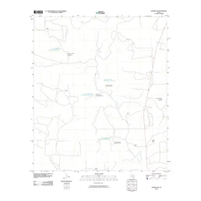
2010 Map of Sonora NW
USGS Topo · Published 2010About this map
The Dry Devils River carves through this northern Sutton County landscape, a region defined by extensive ranching operations and water management infrastructure. Established family holdings such as Jones Ranch, Nixon Ranch, and Davis Ranch are interconnected by a network of rural routes including Davis Rd and SCR 108. The terrain is significantly altered by early 21st-century conservation efforts, evidenced by numerous man-made features like the Soil Conservation Service Site 4 Reservoir and its associated Soil Conservation Service Site 4 Dam. These reservoirs, part of a broader water management system that includes Soil Conservation Service Site 7 Reservoir and several other numbered sites, indicate the critical nature of soil and water preservation in this arid portion of the Edwards Plateau. Further south, Meckel Draw and the Meckel Ranch mark the transition toward the local headwaters, providing a look at land use patterns in the Texas hill country.
Find a feature on this map
19 named features on this map. Tap any name to fly to it.
Don’t see what you’re looking for? This feature index may not catch every label — zoom into the map to look around manually.
Map Details
Editions of this 2010 Sonora NW Map
This is the sole edition of this map. No revisions or reprints were ever made.
Other maps of this area

1954 · Sonora
USGS Topo · 1:250,000

1958 · Sonora
USGS Topo · 1:250,000

1964 · Sonora
USGS Topo · 1:24,000

1964 · Sonora SE
USGS Topo · 1:24,000

1964 · Sonora NE
USGS Topo · 1:24,000

1964 · Eldorado SW
USGS Topo · 1:24,000

1964 · Sonora NW
USGS Topo · 1:24,000

1964 · Coupe Ranch
USGS Topo · 1:24,000
1964 · Eldorado
USGS Topo · 1:24,000

1967 · Savell Ranch
USGS Topo · 1:24,000