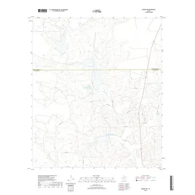
2019 Map of Sonora NW
USGS Topo · Published 2019About this map
Dry Devils River defines the drainage patterns of this high plains landscape, cutting through the Edwards Plateau where Schleicher and Sutton counties meet. The arid environment is characterized by ephemeral water systems like Meckel Draw and engineered water management, notably the Soil Conservation Service Site 4 Reservoir and Soil Conservation Service Site 7 Reservoir. This map documents a modern network of private and county roads, including Co RD 113 and PVT RD 1158, which provide access across the vast ranchlands. The topography is defined by intricate contouring that illustrates the many small draws and ridges typical of the West Texas Divide region, showing how human infrastructure adapts to the natural desert-scrub geography.
Find a feature on this map
17 named features on this map. Tap any name to fly to it.
Don’t see what you’re looking for? This feature index may not catch every label — zoom into the map to look around manually.
Map Details
Editions of this 2019 Sonora NW Map
This is the sole edition of this map. No revisions or reprints were ever made.
Other maps of this area

1954 · Sonora
USGS Topo · 1:250,000

1958 · Sonora
USGS Topo · 1:250,000

1964 · Sonora
USGS Topo · 1:24,000

1964 · Sonora SE
USGS Topo · 1:24,000

1964 · Sonora NE
USGS Topo · 1:24,000

1964 · Eldorado SW
USGS Topo · 1:24,000

1964 · Sonora NW
USGS Topo · 1:24,000

1964 · Coupe Ranch
USGS Topo · 1:24,000
1964 · Eldorado
USGS Topo · 1:24,000

1967 · Savell Ranch
USGS Topo · 1:24,000