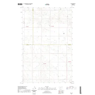
2020 Map of Soo
USGS Topo · Published 2020About this map
Faith Lutheran Cem sits near the northern edge of this high plains landscape, serving as a quiet landmark where Wanso Rd and several three-county borders meet. This 2020 survey documents the intersection of Daniels, Sheridan, and Roosevelt Counties, a region defined by agricultural grid lines and the subtle drainage patterns of Burshia Coulee and Smoke Cr. The network of local routes like Welliver Rd and Risa Rd reveals the persistent homesteading and ranching patterns of the Brockton District. While the terrain is primarily open, the intricate contouring captures the breaks and coulees that provide relief to the upland topography. For those studying northeastern Montana family history, the map provides precise locations for rural infrastructure and cemetery sites that have anchored this remote community for generations.
Find a feature on this map
19 named features on this map. Tap any name to fly to it.
Don’t see what you’re looking for? This feature index may not catch every label — zoom into the map to look around manually.
Map Details
Editions of this 2020 Soo Map
This is the sole edition of this map. No revisions or reprints were ever made.
Other maps of this area

1909 · Smoke Creek
USGS Topo · 1:62,500

1912 · Hay Creek
USGS Topo · 1:62,500

1912 · Smoke Creek
USGS Topo · 1:62,500

1954 · Wolf Point
USGS Topo · 1:250,000

1958 · Wolf Point
USGS Topo · 1:250,000

1973 · Pleasant Prairie
USGS Topo · 1:24,000

1973 · Pleasant Prairie NE
USGS Topo · 1:24,000

1982 · Culbertson
USGS Topo · 1:100,000
1983 · Hay Creek
USGS Topo · 1:24,000
1983 · Smoke Creek NE
USGS Topo · 1:24,000