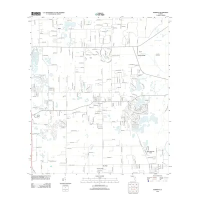
2012 Map of Sorrento
USGS Topo · Published 2012About this map
Seminole Springs and the surrounding Lake County landscape are defined by a complex network of small lakes and springs as they appeared in 2012. This survey illustrates the residential expansion of communities like Mount Plymouth Lakes and Bay Ridge, where modern suburban street patterns contrast with the traditional landmarks of the area's earlier rural identity. Genealogists will find several burial grounds documented here, including Seneca Cem, Seminole Cem, and Sorrento Cem, reflecting the historic settlement nodes of the region.
Find a feature on this map
254 named features on this map. Tap any name to fly to it.
Don’t see what you’re looking for? This feature index may not catch every label — zoom into the map to look around manually.
Map Details
Editions of this 2012 Sorrento Map
This is the sole edition of this map. No revisions or reprints were ever made.
Other maps of this area

1955 · Orlando
USGS Topo · 1:250,000

1957 · Orlando
USGS Topo · 1:250,000

1958 · Orlando
USGS Topo · 1:250,000

1959 · Forest City
USGS Topo · 1:24,000

1960 · Sorrento
USGS Topo · 1:24,000

1960 · Apopka
USGS Topo · 1:24,000

1962 · Orlando
USGS Topo · 1:250,000

1962 · Pine Lakes
USGS Topo · 1:24,000

1962 · Astatula
USGS Topo · 1:24,000
1965 · Sanford SW
USGS Topo · 1:24,000