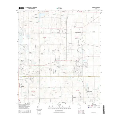
2015 Map of Sorrento
USGS Topo · Published 2015About this map
Mount Plymouth and Sorrento anchor this landscape, where the sandy soils of the Mount Dora ridge meet a dense network of lakes and springs. The layout reflects a mix of citrus-era settlements and later suburban development, with older residential footprints preserved in communities like Tangerine and the vanished hamlet of Seneca. Genealogists can locate several local burial grounds, including Tangerine Cem and the Seminole Cem near Seminole Springs. Transportation is defined by a grid of local roads and the Tangerine Airport, situated just north of the Lake County and Orange County boundary line. The topography is dotted with diverse water bodies such as Lake Seneca, Adams Lake, and the winding Rock Springs Run, illustrating the region's complex karst hydrology before modern drainage altered the flow of Wolf Br and Seminole Cr.
Find a feature on this map
177 named features on this map. Tap any name to fly to it.
Don’t see what you’re looking for? This feature index may not catch every label — zoom into the map to look around manually.
Map Details
Editions of this 2015 Sorrento Map
This is the sole edition of this map. No revisions or reprints were ever made.
Other maps of this area

1955 · Orlando
USGS Topo · 1:250,000

1957 · Orlando
USGS Topo · 1:250,000

1958 · Orlando
USGS Topo · 1:250,000

1959 · Forest City
USGS Topo · 1:24,000

1960 · Sorrento
USGS Topo · 1:24,000

1960 · Apopka
USGS Topo · 1:24,000

1962 · Orlando
USGS Topo · 1:250,000

1962 · Pine Lakes
USGS Topo · 1:24,000

1962 · Astatula
USGS Topo · 1:24,000
1965 · Sanford SW
USGS Topo · 1:24,000