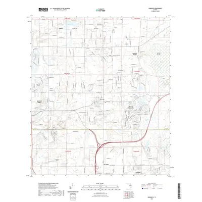
2021 Map of Sorrento
USGS Topo · Published 2021About this map
The unincorporated community of Sorrento serves as a central hub on this map, situated in a landscape defined by an intricate network of freshwater lakes and low-lying wetlands. The area is characterized by significant genealogical interest, evidenced by numerous burial grounds including Sorrento Cem, Bay Ridge Cem, and Tangerine Cem. To the north, the settlement of Seneca is established near Lake Seneca, while Mount Plymouth sits adjacent to Mount Plymouth Lake and Adams Lake. A distinct shift in the landscape occurs to the east within Seminole Swamp, where Rock Springs Run and Seminole Creek flow through the terrain. Evidence of local aviation history is preserved at the Tangerine Airport, located near the southern boundary between Lake and Orange counties. The map illustrates a transition from the structured residential developments near Mount Dora and Apopka to the more hydrologically complex areas around Sulphur Spring and Dropy Spring.
Find a feature on this map
239 named features on this map. Tap any name to fly to it.
Don’t see what you’re looking for? This feature index may not catch every label — zoom into the map to look around manually.
Map Details
Editions of this 2021 Sorrento Map
This is the sole edition of this map. No revisions or reprints were ever made.
Other maps of this area

1955 · Orlando
USGS Topo · 1:250,000

1957 · Orlando
USGS Topo · 1:250,000

1958 · Orlando
USGS Topo · 1:250,000

1959 · Forest City
USGS Topo · 1:24,000

1960 · Sorrento
USGS Topo · 1:24,000

1960 · Apopka
USGS Topo · 1:24,000

1962 · Orlando
USGS Topo · 1:250,000

1962 · Pine Lakes
USGS Topo · 1:24,000

1962 · Astatula
USGS Topo · 1:24,000
1965 · Sanford SW
USGS Topo · 1:24,000