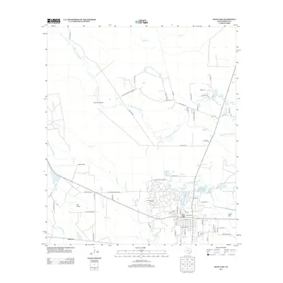
2013 Map of Sour Lake
USGS Topo · Published 2013About this map
The Sour Lake Dome Oil Field defines the industrial footprint of this Hardin County landscape, where the town of Sour Lake is situated over a massive salt dome that historically fueled the regional oil boom. The map documents the intricate grid of the settlement, from S Fannin St to N Ann St, as it borders the natural hydrology of The Sour Lakes. To the north, the Big Thicket National Preserve protects the wetlands around Little Pine Island Bayou, a stark contrast to the nearby extraction infrastructure. In the southwestern reaches, the rural character persists through Jones Prairie and Pelt Prairie, while genealogists will find the Rosedale Cem located south of the main town site. This survey also records numerous local water bodies such as Bushy Lake and Grassy Lake, alongside the small community of Hathaway near the southern margin.
Find a feature on this map
67 named features on this map. Tap any name to fly to it.
Don’t see what you’re looking for? This feature index may not catch every label — zoom into the map to look around manually.
Map Details
Editions of this 2013 Sour Lake Map
This is the sole edition of this map. No revisions or reprints were ever made.
Other maps of this area

1943 · Liberty
USGS Topo · 1:125,000

1954 · Beaumont
USGS Topo · 1:250,000

1955 · Daisetta
USGS Topo · 1:62,500

1955 · Saratoga
USGS Topo · 1:62,500

1955 · Kountze
USGS Topo · 1:62,500

1955 · Sour Lake
USGS Topo · 1:62,500

1957 · Beaumont
USGS Topo · 1:250,000

1984 · Beaumont
USGS Topo · 1:250,000
1984 · Nome
USGS Topo · 1:24,000

1984 · Sour Lake
USGS Topo · 1:24,000