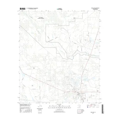
2016 Map of Sour Lake
USGS Topo · Published 2016About this map
Sour Lake serves as the focal point of this Hardin County landscape, where the town site meets the sprawling wetlands and forests of the Big Thicket National Preserve. The geography is defined by a dense network of watercourses including Little Pine Island Bayou, Black Cr, and Tenmile Gully, which thread through the low-lying terrain. To the west, the landscape opens into Jones Prairie and Pelt Prairie, reflecting the varied ecological zones of southeast Texas. Local history is anchored by Rosedale Cem and the namesake The Sour Lakes, water bodies that historically drew travelers to the area for their mineral properties. The map also documents modern development and rural connectivity, with detailed street grids in Sour Lake and remote routes like Old Batson Saratoga Rd and Wilkins Ranch Rd extending into the surrounding thickets and prairies.
Find a feature on this map
69 named features on this map. Tap any name to fly to it.
Don’t see what you’re looking for? This feature index may not catch every label — zoom into the map to look around manually.
Map Details
Editions of this 2016 Sour Lake Map
This is the sole edition of this map. No revisions or reprints were ever made.
Other maps of this area

1943 · Liberty
USGS Topo · 1:125,000

1954 · Beaumont
USGS Topo · 1:250,000

1955 · Daisetta
USGS Topo · 1:62,500

1955 · Saratoga
USGS Topo · 1:62,500

1955 · Kountze
USGS Topo · 1:62,500

1955 · Sour Lake
USGS Topo · 1:62,500

1957 · Beaumont
USGS Topo · 1:250,000

1984 · Beaumont
USGS Topo · 1:250,000
1984 · Nome
USGS Topo · 1:24,000

1984 · Sour Lake
USGS Topo · 1:24,000