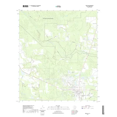
2019 Map of Sour Lake
USGS Topo · Published 2019About this map
Sour Lake serves as the primary hub in this Southeast Texas landscape, situated at a junction of roads and waterways where the coastal plain meets the dense woodlands of the Big Thicket National Preserve. The map reveals a transition between open spaces like Jones Prairie and Pelt Prairie and the intricate drainage networks of Little Pine Island Bayou and Pine Island Bayou. Within the township, the street grid is well-defined, leading past the local Po and toward the Rosedale Cem on the southern edge. The area's namesake water features, including The Sour Lakes, Bushy Lake, and Grassy Lake, are clearly delineated, illustrating the wet, low-lying character of the Hardin County terrain. Rural connections like Old Batson Saratoga Rd and Rosier Park Rd tie the town to the surrounding preserves and outlying residential pockets like Aquarius and Tallow Ests.
Find a feature on this map
63 named features on this map. Tap any name to fly to it.
Don’t see what you’re looking for? This feature index may not catch every label — zoom into the map to look around manually.
Map Details
Editions of this 2019 Sour Lake Map
This is the sole edition of this map. No revisions or reprints were ever made.
Other maps of this area

1943 · Liberty
USGS Topo · 1:125,000

1954 · Beaumont
USGS Topo · 1:250,000

1955 · Daisetta
USGS Topo · 1:62,500

1955 · Saratoga
USGS Topo · 1:62,500

1955 · Kountze
USGS Topo · 1:62,500

1955 · Sour Lake
USGS Topo · 1:62,500

1957 · Beaumont
USGS Topo · 1:250,000

1984 · Beaumont
USGS Topo · 1:250,000
1984 · Nome
USGS Topo · 1:24,000

1984 · Sour Lake
USGS Topo · 1:24,000