
1983 Map of South Bend
USGS Topo · Published 1984About this map
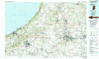
The St. Joseph River anchors this regional portrait of the Michiana borderland during the early 1980s, flowing through the industrial and academic heart of South Bend and Mishawaka. The landscape is defined by the convergence of major transportation corridors, including the Indiana Toll Road and a dense network of railroads such as Conrail and the Chicago South Shore and South Bend. Educational landmarks are prominent, notably the University of Notre Dame and St Marys College, which sit just north of the urban center. Along the Lake Michigan shoreline, the map details the protected environments of the Indiana Dunes National Lakeshore and Warren Dunes State Park. This planimetric study captures the area's transition from the heavy manufacturing centers of Elkhart and Michigan City to the surrounding agricultural fields and the marshy expanses of the Kankakee State Fish and Wildlife Area.
Find a feature on this map
206 named features on this map. Tap any name to fly to it.
Don’t see what you’re looking for? This feature index may not catch every label — zoom into the map to look around manually.
Map Details
Editions of this 1983 South Bend Map
2 editions found
Historical Maps of South Bend Through Time
1 maps found