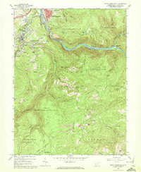
1964 Map of South Connellsville
USGS Topo · Published 1972About this map
The Youghiogheny River carves a deep path through the north-central portion of this landscape, separating the industrial activity of South Connellsville from the dense woodlands of State Game Lands No 51. To the west, the settlement of Dunbar and its surrounding clusters like Factory Hill, Furnace Hill, and Pechin reflect a region defined by its resource extraction and manufacturing history. The presence of an Iron Furnace and numerous labels for strip mines and quarries alongside the B & O and Baltimore and Ohio Maryland and Western rail lines underscores the heavy industrial character of the era. High atop Chestnut Ridge, the map shifts toward rural landmarks such as Greenbrier Ch and the Tharp Cem, providing essential points of interest for genealogists tracing family histories in the outlying flats and hollows of Dunbar and Stewart townships.
Find a feature on this map
57 named features on this map. Tap any name to fly to it.
Don’t see what you’re looking for? This feature index may not catch every label — zoom into the map to look around manually.
Map Details
Editions of this 1964 South Connellsville Map
4 editions found
Other maps of this area

1900 · Uniontown
USGS Topo · 1:62,500

1902 · Connellsville
USGS Topo · 1:62,500

1922 · Confluence
USGS Topo · 1:62,500

1922 · Donegal
USGS Topo · 1:62,500

1931 · Connellsville
USGS Topo · 1:62,500

1931 · Uniontown
USGS Topo · 1:62,500

1931 · Confluence
USGS Topo · 1:62,500

1933 · Confluence
USGS Topo · 1:62,500

1935 · Donegal
USGS Topo · 1:62,500

1936 · Connellsville
USGS Topo · 1:62,500
Featured Places
- South Connellsville, PA
- Dunbar, PA
- Springfield Township, PA
- Reservoir Hill, PA
- Connellsville Township, PA