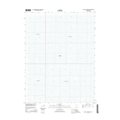
2014 Map of South of Arinosa SW
USGS Topo · Published 2014About this map
The Great Salt Lake Desert dominates this 2014 survey of Tooele County, Utah, appearing as a minimalist landscape defined by subtle elevation changes and expansive salt flats. This topographic study captures a portion of the eastern basin where the environment is characterized by its extreme flatness and lack of surface features. The survey highlights the Public Land Survey System grid across two townships and two ranges, including t4s r17w, t4s r16w, t5s r17w, and t5s r16w. This specific location represents the stark reality of the Utah desert, where the map's contours are few and far between, reflecting a territory where survival and navigation rely on precise surveying rather than prominent landmarks. It remains a starkly industrial or military buffer zone, largely devoid of permanent human habitation or named infrastructure.
Find a feature on this map
5 named features on this map. Tap any name to fly to it.
Don’t see what you’re looking for? This feature index may not catch every label — zoom into the map to look around manually.
Map Details
Editions of this 2014 South of Arinosa SW Map
This is the sole edition of this map. No revisions or reprints were ever made.
Other maps of this area

1953 · Tooele
USGS Topo · 1:250,000

1955 · Tooele
USGS Topo · 1:250,000
1972 · Elephant Knoll NE
USGS Topo · 1:24,000

1972 · Elephant Knoll SE
USGS Topo · 1:24,000

1973 · Arinosa SE
USGS Topo · 1:24,000

1973 · Arinosa SW
USGS Topo · 1:24,000

1973 · Salduro SE
USGS Topo · 1:24,000

1973 · Gold Hill 1 SE
USGS Topo · 1:24,000

1973 · Gold Hill 1 SW
USGS Topo · 1:24,000

1973 · Gold Hill 1 NE
USGS Topo · 1:24,000