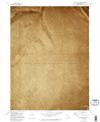
1973 Map of South of Big Pass
USGS Topo · Published 1995About this map
Utah Test and Training Range North dominates this orthophotomosaic, reflecting the mid-1970s military use of the Great Salt Lake Desert. The imagery reveals the stark reality of the Mud Flat terrain, a landscape defined by expansive salt crusts and seasonal inundation rather than traditional topography. This specific area spans the jurisdictional boundary between Box Elder Co and Tooele Co, where the featureless surface served as a controlled environment for testing and training operations. The orthophoto format provides a literal photographic perspective of the surface textures and isolation of the region, emphasizing how the desert's natural uniformity was repurposed for national defense activities during the Cold War era.
Find a feature on this map
3 named features on this map. Tap any name to fly to it.
Don’t see what you’re looking for? This feature index may not catch every label — zoom into the map to look around manually.
Map Details
Editions of this 1973 South of Big Pass Map
2 editions found
Other maps of this area

1953 · Tooele
USGS Topo · 1:250,000

1954 · Brigham City
USGS Topo · 1:250,000

1955 · Tooele
USGS Topo · 1:250,000

1958 · Brigham City
USGS Topo · 1:250,000

1962 · Brigham City
USGS Topo · 1:250,000

1973 · Knolls 2 NW
USGS Topo · 1:24,000

1973 · Floating Island SE
USGS Topo · 1:24,000

1973 · Knolls 2 NE
USGS Topo · 1:24,000

1973 · Floating Island NE
USGS Topo · 1:24,000

1973 · Knolls 2 SW
USGS Topo · 1:24,000