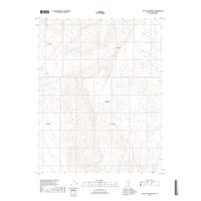
2018 Map of South of Delamar Lake
USGS Topo · Published 2018About this map
Delamar Mountains dominate this high-desert landscape in Lincoln County, Nevada, where the complex topography is defined by intricate ridgelines and dry drainage patterns. The map captures the southern extent of this range, characterized by steep elevation changes and the winding course of Pahranagat Wash in the northwestern portion of the quadrangle. This area reflects the extreme arid conditions typical of southeastern Nevada, where land management is divided into public land survey sections like t9s r62e and t9s r63e. The absence of developed roads or permanent settlements emphasizes the region's character as a primitive corridor through the Great Basin, primarily used for grazing or transit between more established basin floors.
Find a feature on this map
6 named features on this map. Tap any name to fly to it.
Don’t see what you’re looking for? This feature index may not catch every label — zoom into the map to look around manually.
Map Details
Editions of this 2018 South of Delamar Lake Map
This is the sole edition of this map. No revisions or reprints were ever made.
Other maps of this area

1885 · Pioche
USGS Topo · 1:250,000

1886 · Pioche
USGS Topo · 1:250,000

1945 · Alamo
USGS Topo · 1:125,000

1954 · Caliente
USGS Topo · 1:250,000

1959 · Caliente
USGS Topo · 1:250,000

1969 · Alamo SE
USGS Topo · 1:24,000
1969 · Delamar 3 SE
USGS Topo · 1:24,000

1969 · Gregerson Basin
USGS Topo · 1:24,000

1969 · Delamar 3 NE
USGS Topo · 1:24,000
1969 · Delamar 3 SW
USGS Topo · 1:24,000