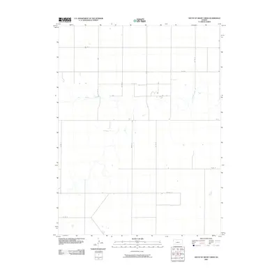
2009 Map of South of Drury Creek
USGS Topo · Published 2009About this map
Little Beaver Creek meanders through this agricultural landscape in Sherman County, Kansas, defining the natural drainage patterns of the High Plains. The landscape is primarily organized by a rigid grid of rural thoroughfares, including Co Rd D and Co Rd 16, which facilitate movement between scattered homesteads and farming operations. This geometry reflects the enduring influence of the Public Land Survey System on the central United States. While water is a defining feature here, it is seasonal and localized, as seen in the various tributaries and unnamed stock ponds that dot the territory near Co Rd C. The absence of large urban centers highlights the area's rural character at the start of the twenty-first century, where infrastructure like Co Rd 12 and Co Rd 14 serves as the primary backbone for local transit and resource management.
Find a feature on this map
13 named features on this map. Tap any name to fly to it.
Don’t see what you’re looking for? This feature index may not catch every label — zoom into the map to look around manually.
Map Details
Editions of this 2009 South of Drury Creek Map
This is the sole edition of this map. No revisions or reprints were ever made.
Other maps of this area

1951 · Bird City South
USGS Topo · 1:62,500

1952 · St Francis 3
USGS Topo · 1:62,500

1954 · Goodland
USGS Topo · 1:250,000

1956 · Goodland
USGS Topo · 1:250,000

1957 · Goodland
USGS Topo · 1:250,000

1966 · Goodland NW
USGS Topo · 1:24,000

1966 · Ruleton NW
USGS Topo · 1:24,000

1966 · Ruleton NE
USGS Topo · 1:24,000
1978 · Crosby Creek
USGS Topo · 1:24,000
1978 · St. Francis 3 SE
USGS Topo · 1:24,000