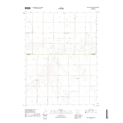
2018 Map of South of Drury Creek
USGS Topo · Published 2018About this map
Little Beaver Creek carves a subtle path through the High Plains landscape of Northwest Kansas, providing the primary topographic relief in this section of the state. This 2018 survey documents a strictly ordered agricultural grid where the boundary between Cheyenne County and Sherman County is defined by the straight line of County Road 80. The terrain is characterized by broad plateaus and gentle drainage basins, largely dictated by the Public Land Survey System sections. A network of section-line roads, including County Road D and County Road 77, connects the occasional homestead or farmstead in this sparsely populated region. The map captures the persistence of the traditional township and range system, showing how modern county infrastructure maintains the legacy of the original land grants and settlement patterns on the open prairie.
Find a feature on this map
20 named features on this map. Tap any name to fly to it.
Don’t see what you’re looking for? This feature index may not catch every label — zoom into the map to look around manually.
Map Details
Editions of this 2018 South of Drury Creek Map
This is the sole edition of this map. No revisions or reprints were ever made.
Other maps of this area

1951 · Bird City South
USGS Topo · 1:62,500

1952 · St Francis 3
USGS Topo · 1:62,500

1954 · Goodland
USGS Topo · 1:250,000

1956 · Goodland
USGS Topo · 1:250,000

1957 · Goodland
USGS Topo · 1:250,000

1966 · Goodland NW
USGS Topo · 1:24,000

1966 · Ruleton NW
USGS Topo · 1:24,000

1966 · Ruleton NE
USGS Topo · 1:24,000
1978 · Crosby Creek
USGS Topo · 1:24,000
1978 · St. Francis 3 SE
USGS Topo · 1:24,000