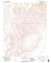
1969 Map of South of Gregerson Basin
USGS Topo · Published 1995About this map
The high desert landscape of Lincoln County is defined here by the steep, deeply eroded eastern slopes of the Delamar Mountains as they descend into the Kane Springs Valley. This 1960s survey captures the region's absolute reliance on sparse water infrastructure in a high-elevation arid environment. Evidence of ranching and land management is sparse but critical, found in the high Pony Reservoir and a remote Well 4642 located in the northeastern heights. The mapping includes detailed surveying of topographic relief, showing the complex drainage patterns that feed the valley floor. A single Water Tank stands as a lonely landmark along the western ridges, while fine dashed lines across the terrain indicate selected fence lines, marking the quiet human imprint on this expansive public land.
Find a feature on this map
5 named features on this map. Tap any name to fly to it.
Don’t see what you’re looking for? This feature index may not catch every label — zoom into the map to look around manually.
Map Details
Editions of this 1969 South of Gregerson Basin Map
2 editions found
Other maps of this area

1885 · Pioche
USGS Topo · 1:250,000

1886 · Pioche
USGS Topo · 1:250,000

1954 · Caliente
USGS Topo · 1:250,000

1959 · Caliente
USGS Topo · 1:250,000

1969 · Vigo NW
USGS Topo · 1:24,000
1969 · Delamar 3 SE
USGS Topo · 1:24,000

1969 · Gregerson Basin
USGS Topo · 1:24,000

1969 · Delamar 3 NE
USGS Topo · 1:24,000
1969 · Delamar 3 SW
USGS Topo · 1:24,000
1969 · Sunflower Mtn
USGS Topo · 1:24,000