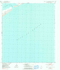
1952 Map of South of Palacios Point
USGS Topo · Published 1991About this map
Matagorda Peninsula forms a narrow, shifting barrier between the open waters of the Gulf of Mexico and the protected reaches of Matagorda Bay. This mid-century coastal survey, based on 1952 fieldwork, illustrates a landscape defined by water and maritime transit rather than terrestrial settlement. A solitary Windmill stands as one of the few man-made landmarks on the peninsula, hinting at the cattle grazing or light ranching activity that historically occupied these sandy stretches.
Find a feature on this map
5 named features on this map. Tap any name to fly to it.
Don’t see what you’re looking for? This feature index may not catch every label — zoom into the map to look around manually.
Map Details
Editions of this 1952 South of Palacios Point Map
2 editions found
Other maps of this area

1952 · Palacios SE
USGS Topo · 1:24,000

1952 · Palacios Point
USGS Topo · 1:24,000

1952 · South of Palacios Point
USGS Topo · 1:24,000

1952 · Decros Point
USGS Topo · 1:24,000

1953 · Beeville
USGS Topo · 1:250,000

1956 · Beeville
USGS Topo · 1:250,000

1960 · Beeville
USGS Topo · 1:250,000
1980 · Carancahua Pass
USGS Topo · 1:24,000
1983 · San Antonio Bay
USGS Topo · 1:100,000
1984 · Port Lavaca
USGS Topo · 1:100,000