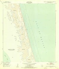
1951 Map of South of Potrero Lopeno NE
USGS Topo · Published 1955About this map
Padre Island forms a long, slender barrier between the open waters of the Gulf of Mexico and the shallow expanse of the Laguna Madre. This 1951 survey reveals a landscape almost entirely shaped by wind and tide, dominated by extensive sand flats and numerous shifting sand dunes reaching elevations up to 27 feet. The isolation of this stretch of the Texas coast is evident, with only small markers like Blanco and Boiler providing reference points for navigation or coastal exploration.
Find a feature on this map
13 named features on this map. Tap any name to fly to it.
Don’t see what you’re looking for? This feature index may not catch every label — zoom into the map to look around manually.
Map Details
Editions of this 1951 South of Potrero Lopeno NE Map
2 editions found
Other maps of this area

1923 · Lopena Island
USGS Topo · 1:62,500

1951 · South of Potrero Lopeno NE
USGS Topo · 1:24,000

1952 · Potrero Lopeno SE
USGS Topo · 1:24,000

1952 · South of Potrero Lopeno NW
USGS Topo · 1:24,000

1952 · South of Potrero Lopeno SE
USGS Topo · 1:24,000

1952 · Port Mansfield
USGS Topo · 1:24,000

1952 · Potrero Lopeno SW
USGS Topo · 1:24,000

1952 · Potrero Lopeno
USGS Topo · 1:62,500

1952 · South of Potrero Lopeno
USGS Topo · 1:62,500

1953 · Brownsville
USGS Topo · 1:250,000