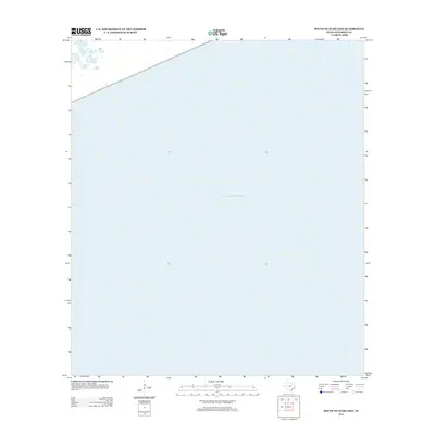
2013 Map of South of Star Lake
USGS Topo · Published 2013About this map
The Gulf of Mexico dominates this maritime expanse off the coast of Jefferson County, Texas. This survey primarily charts the open waters and the transition from sea to land along the state's southeastern edge. The coastline is navigated by State Highway 87, which runs parallel to the shore in the northwestern corner of the quadrangle. This map is particularly useful for maritime historians or researchers tracking the shifting shoreline and coastal access roads along this stretch of the Texas coast during the early twenty-first century. The lack of interior landmarks emphasizes the area's exposure to the sea and its importance as a navigational boundary.
Find a feature on this map
2 named features on this map. Tap any name to fly to it.
Don’t see what you’re looking for? This feature index may not catch every label — zoom into the map to look around manually.
Map Details
Editions of this 2013 South of Star Lake Map
This is the sole edition of this map. No revisions or reprints were ever made.
Other maps of this area

1950 · Houston
USGS Topo · 1:250,000

1956 · Houston
USGS Topo · 1:250,000

1961 · Star Lake
USGS Topo · 1:24,000

1961 · Mud Lake
USGS Topo · 1:24,000
1961 · Clam Lake
USGS Topo · 1:24,000
1962 · Whites Ranch
USGS Topo · 1:24,000
1962 · South of Star Lake
USGS Topo · 1:24,000

1975 · Houston
USGS Topo · 1:250,000
1983 · Galveston
USGS Topo · 1:100,000
1983 · Anahuac
USGS Topo · 1:100,000