
1961 Map of Mud Lake
USGS Topo · Published 1964About this map
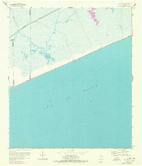
Mud Bayou winds through a complex coastal marshland on this 1961 survey, revealing the shifting boundary between the Texas mainland and the open Gulf of Mexico. This low-lying landscape is defined by its water management and maritime transit, most notably the Intracoastal Waterway cutting straight across the northern marsh. The transition from the inland Mud Lake and the North Prong to the sandy shoreline is marked by subtle human interventions, including a lone Gate, a navigational Turn, and a location noted simply as Shell. These features, along with a stretch of Highway 87, illustrate the era's sparse coastal development along the border of Jefferson and Chambers counties before later environmental shifts and modern infrastructure reshaped the shoreline.
Find a feature on this map
11 named features on this map. Tap any name to fly to it.
Don’t see what you’re looking for? This feature index may not catch every label — zoom into the map to look around manually.
Map Details
Editions of this 1961 Mud Lake Map
2 editions found
Other maps of this area

1931 · High Island
USGS Topo · 1:24,000

1943 · High Island
USGS Topo · 1:31,680

1943 · Sea Breeze
USGS Topo · 1:24,000

1945 · Sea Breeze
USGS Topo · 1:31,680

1950 · Houston
USGS Topo · 1:250,000

1956 · Houston
USGS Topo · 1:250,000

1961 · Star Lake
USGS Topo · 1:24,000
1962 · High Island
USGS Topo · 1:24,000
1962 · Stanolind Reservoir
USGS Topo · 1:24,000
1962 · Whites Ranch
USGS Topo · 1:24,000