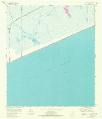
1961 Map of Mud Lake
USGS Topo · Published 1978About this map
The Gulf of Mexico coast along the Jefferson and Chambers county line is defined by a low-lying marshland environment where the Intracoastal Waterway cuts a straight path across the landscape. This 1961 survey, based on earlier planetable data and updated with 1974 aerial photogrammetry, reveals the intricate hydrological network of Mud Bayou as it meanders toward the tidal waters of Mud Lake. The presence of the highway 87 provides the primary terrestrial link across this wetland region, running parallel to the shoreline. The map documents the shifting boundary lines between Chambers and Jefferson counties, offering a detailed look at the coastal geography before modern shoreline changes or industrial developments further altered the drainage patterns of the Texas coast.
Find a feature on this map
7 named features on this map. Tap any name to fly to it.
Don’t see what you’re looking for? This feature index may not catch every label — zoom into the map to look around manually.
Map Details
Editions of this 1961 Mud Lake Map
2 editions found
Other maps of this area

1931 · High Island
USGS Topo · 1:24,000

1943 · High Island
USGS Topo · 1:31,680

1943 · Sea Breeze
USGS Topo · 1:24,000

1945 · Sea Breeze
USGS Topo · 1:31,680

1950 · Houston
USGS Topo · 1:250,000

1956 · Houston
USGS Topo · 1:250,000

1961 · Star Lake
USGS Topo · 1:24,000

1961 · Mud Lake
USGS Topo · 1:24,000
1962 · High Island
USGS Topo · 1:24,000
1962 · Stanolind Reservoir
USGS Topo · 1:24,000