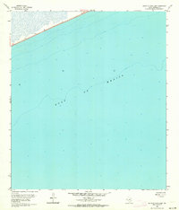
1962 Map of South of Star Lake
USGS Topo · Published 1964About this map
The Gulf of Mexico dominates this coastal survey of the Jefferson County shoreline, documenting the transition between land and sea in the early 1960s. The map illustrates a narrow strip of land along the upper Texas coast, where the state highway 87 skirts the water's edge. This specific coastal segment is characterized by its emerging industrial presence, highlighted by the offshore Oil Well located west of the central meridian. Compiled from hydrographic data and photogrammetric methods, the sheet provides a record of the shifting shoreline and bathymetry just south of Star Lake during a period of active offshore exploration. The sounding data reveals the gradual deepening of the gulf floor, essential for understanding the maritime geography of the region before subsequent decades of coastal erosion and development.
Find a feature on this map
3 named features on this map. Tap any name to fly to it.
Don’t see what you’re looking for? This feature index may not catch every label — zoom into the map to look around manually.
Map Details
Editions of this 1962 South of Star Lake Map
2 editions found
Other maps of this area

1950 · Houston
USGS Topo · 1:250,000

1956 · Houston
USGS Topo · 1:250,000

1961 · Star Lake
USGS Topo · 1:24,000

1961 · Mud Lake
USGS Topo · 1:24,000
1961 · Clam Lake
USGS Topo · 1:24,000
1962 · Whites Ranch
USGS Topo · 1:24,000

1975 · Houston
USGS Topo · 1:250,000
1983 · Galveston
USGS Topo · 1:100,000
1983 · Anahuac
USGS Topo · 1:100,000
1993 · Whites Ranch
USGS Topo · 1:24,000