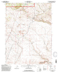
1991 Map of South Pass City
USGS Topo · Published 1997About this map
South Pass City stands as a focal point of Wyoming's mining heritage in this late-twentieth-century record of the Lander Ranger District. Located within the Shoshone National Forest, the area is densely marked with the remnants of gold-seeking industry. Significant sites like the Carissa Mine, King Solomon Mine, and Duncan Mine are documented along the rugged drainages of Willow Creek and Hermit Gulch.
Find a feature on this map
30 named features on this map. Tap any name to fly to it.
Don’t see what you’re looking for? This feature index may not catch every label — zoom into the map to look around manually.
Map Details
Editions of this 1991 South Pass City Map
This is the sole edition of this map. No revisions or reprints were ever made.
Other maps of this area

1953 · Atlantic City
USGS Topo · 1:24,000

1953 · Louis Lake
USGS Topo · 1:24,000

1953 · South Pass City
USGS Topo · 1:24,000

1953 · Christina Lake
USGS Topo · 1:24,000

1954 · Miners Delight
USGS Topo · 1:24,000

1955 · Lander
USGS Topo · 1:250,000

1958 · Lander
USGS Topo · 1:250,000

1958 · Pacific Springs
USGS Topo · 1:24,000

1958 · Dickie Springs
USGS Topo · 1:24,000

1958 · Continental Peak
USGS Topo · 1:24,000