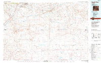
1984 Map of South Pass
USGS Topo · Published 1984About this map
South Pass City and Atlantic City anchor this high-desert landscape in the mid-1980s, marking the historic gateway where the Continental Divide meets the northern reach of the Great Divide Basin. This area is defined by its transit and extraction history, with the paths of the Oregon Trail and Emigrant Trail cutting across the terrain near modern mining operations like the U S Steel facility. The map documents a significant concentration of lode and placer mining history north of the Antelope Hills, including the Franklin Mine, Tabor Grand Mine, and Bullion Mine. Hydrographic patterns are dominated by the Sweetwater River and its numerous tributaries such as Willow Creek and Rock Creek, which contrast with the arid flats of the Alkali Basin and the isolated peaks of Crooks Mountain. This survey provides a look at the intersection of pioneer migration routes and 20th-century industrial use in the Wind River Range foothills.
Find a feature on this map
47 named features on this map. Tap any name to fly to it.
Don’t see what you’re looking for? This feature index may not catch every label — zoom into the map to look around manually.
Map Details
Editions of this 1984 South Pass Map
2 editions found
Other maps of this area

1951 · Soap Holes
USGS Topo · 1:24,000

1951 · Graham Ranch
USGS Topo · 1:24,000

1951 · Crooks Mountain
USGS Topo · 1:24,000

1951 · Myers Ranch
USGS Topo · 1:24,000

1953 · Lewiston Lakes
USGS Topo · 1:24,000

1953 · Barras Springs
USGS Topo · 1:24,000

1953 · Sweetwater Station
USGS Topo · 1:24,000

1953 · Gravel Spring
USGS Topo · 1:24,000

1953 · Happy Spring
USGS Topo · 1:24,000

1953 · Radium Springs
USGS Topo · 1:24,000
Featured Places
- Atlantic City, WY
- South Pass City, WY
- Erramouspe Place, WY
- Last Crossing Ford Number 9, WY
- Rocky Crossing, WY