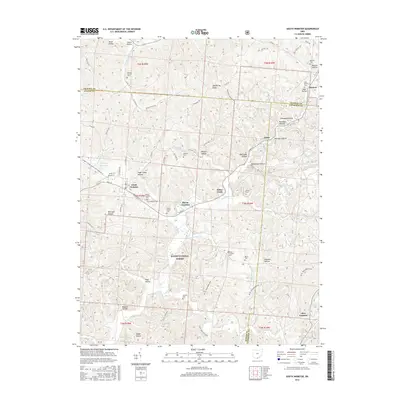
2016 Map of South Webster
USGS Topo · Published 2016About this map
South Webster serves as the primary hub in this southern Ohio landscape, situated at the junction of several local routes like W Main St and Bennett School House South Webster Rd. The topography is defined by narrow ridges and numerous hollows, such as Sugar Camp Hollow and Harrison Hollow, which historically dictated the placement of settlements and small family cemeteries. Much of the southern portion of the quadrangle is occupied by the Wayne National Forest, where the terrain drops into drainage basins for Bloom Furnace Creek and Pine Creek. Evidence of the region's early industrial roots is visible in names like Olive Furnace and Jackson Furnace Cemetery, while local genealogists can trace family footprints through numerous small burial sites including Brant Cemetery and Stidham Cemetery.
Find a feature on this map
78 named features on this map. Tap any name to fly to it.
Don’t see what you’re looking for? This feature index may not catch every label — zoom into the map to look around manually.
Map Details
Editions of this 2016 South Webster Map
This is the sole edition of this map. No revisions or reprints were ever made.
Other maps of this area

1898 · Ironton
USGS Topo · 1:62,500

1900 · Ironton
USGS Topo · 1:62,500

1911 · Sciotoville
USGS Topo · 1:62,500

1912 · Oak Hill
USGS Topo · 1:62,500

1913 · Sciotoville
USGS Topo · 1:62,500

1926 · Greenup
USGS Topo · 1:48,000

1930 · Greenup
USGS Topo · 1:62,500

1957 · Huntington
USGS Topo · 1:250,000

1960 · Huntington
USGS Topo · 1:250,000
1961 · Petersburg
USGS Topo · 1:24,000